


WIHP - South Tangerang / Pondok Cabe
Located in South Tangerang, Indonesia
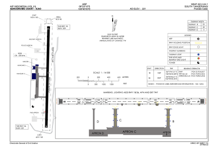
ICAO - WIHP, IATA - PCB
Data provided by AirmateGeneral information
Coordinates: S6°20'10" E106°45'53"
Elevation is 221 feet MSL.
View others Airports in Jakarta Raya
Operational data
Special qualification required
Current time UTC:
Current local time:
Weather at : WIHH - Jakarta/Halim Perdanakusuma ( 15 km )
METAR: WIHH 291600Z 07004KT 8000 NSC 30/26 Q1009 NOSIG METAR
TAF: TAF WIHH 291100Z 2912/3012 09012KT 8000 FEW020 BECMG 2916/2918 00000KT 4000 HZ
Communications frequencies: [VIEW]
Runways:
| RWY identifier | QFU | Length (ft) | Width (ft) | Surface | LDA (ft) |
| 18 | 184° | 6562 | 148 | ASP | |
| 36 | 4° | 6562 | 148 | ASP |
Airport contact information
Address: South Tangerang Indonesia