


WIDD - Batam / Hang Nadim
Located in Batam, Indonesia
ICAO - WIDD, IATA - BTH
Data provided by AirmateGeneral information
Coordinates: N1°7'7" E104°6'50"
Elevation is 128 feet MSL.
View others Airports in Riau
Operational data
Special qualification required
Current time UTC:
Current local time:
Weather
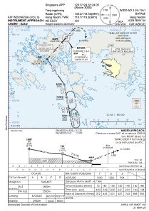
METAR: WIDD 280500Z 21014KT 9999 SCT014 32/26 Q1011 NOSIG
TAF: TAF WIDD 280500Z 2806/2906 20010KT 9000 TS FEW013CB PROB40 TEMPO 2806/2808 5000 -TSRA BECMG 2808/2810 NSW FEW014
Communications frequencies: [VIEW]
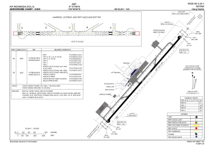
Runways:
| RWY identifier | QFU | Length (ft) | Width (ft) | Surface | LDA (ft) |
| 04 | 42° | 13205 | 148 | ASP | |
| 22 | 222° | 13205 | 148 | ASP |
Airport contact information
Address: Batam Indonesia