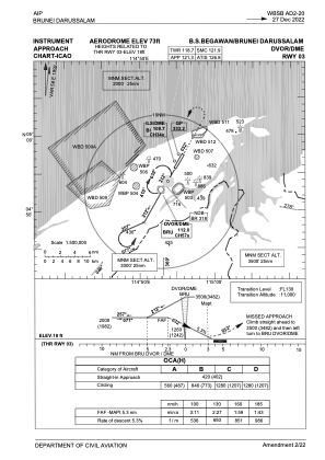
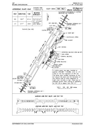


WBSB - Brunei / International
Located in Bandar Seri Begawan, Brunei Darussalam
ICAO - WBSB, IATA - BWN
Data provided by AirmateGeneral information
Coordinates: N4°56'39" E114°55'42"
Elevation is 73 feet MSL.
View others Airports in Brunei-Muara
Operational data
Special qualification required
Current time UTC:
Current local time:
Weather
METAR: WBSB 272300Z 16003KT 9999 FEW004 BKN300 28/28 Q1008 NOSIG
TAF: TAF WBSB 272300Z 2800/2906 22003KT 9999 FEW014 FEW015CB BECMG 2803/2805 32010KT FEW016 TEMPO 2809/2813 5000 TSRA SCT014 FEW015CB
Communications frequencies: [VIEW]
Runways:
| RWY identifier | QFU | Length (ft) | Width (ft) | Surface | LDA (ft) |
| 03 | 31° | 12001 | 151 | ASP | |
| 21 | 211° | 12001 | 151 | ASP |
Airport contact information
Address: Bandar Seri Begawan Brunei Darussalam