


WATO - Labuan Bajo / Komodo
Located in Labuan Bajo, Indonesia
ICAO - WATO, IATA - LBJ
Data provided by AirmateGeneral information
Coordinates: S8°29'11" E119°53'15"
Elevation is 238 feet MSL.
View others Airports in Nusa Tenggara Timur
Operational data
Special qualification required
Current time UTC:
Current local time:
Weather at : - ( 0 km )
METAR: MDST 012318Z 10006KT 070V140 8000 -RA FEW015CB BKN016 BKN070 24/24 Q1010 CB/NE/SE/W/NW/N
Communications frequencies: [VIEW]
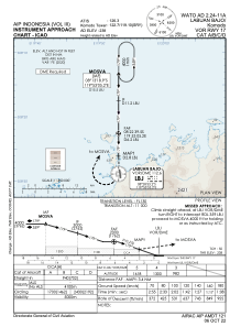
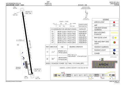
Runways:
| RWY identifier | QFU | Length (ft) | Width (ft) | Surface | LDA (ft) |
| 17 | 172° | 8694 | 148 | ASP | |
| 35 | 352° | 8694 | 148 | ASP |
Airport contact information
Address: Labuan Bajo Indonesia