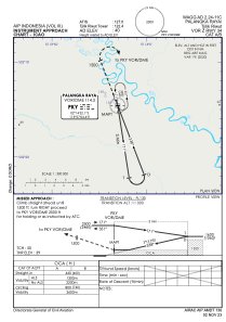
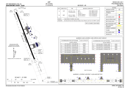


WAGG - Palangka Raya / Tjilik Riwut
Located in Palangka Raya, Indonesia
ICAO - , IATA - PKY
Data provided by AirmateGeneral information
Coordinates: S2°13'36" E113°56'40"
Elevation is 40 feet MSL.
View others Airports in (unassigned)
Operational data
Special qualification required
Current time UTC:
Current local time:
Weather at : - ( 0 km )
METAR: KGXY 280612Z 32005KT 10SM BKN014 OVC065 04/03 A2993 RMK AO2 RAE0559 P0000
Communications frequencies: [VIEW]
Runways:
| RWY identifier | QFU | Length (ft) | Width (ft) | Surface | LDA (ft) |
| 16 | 159° | 8202 | 148 | UNK | |
| 34 | 339° | 8202 | 148 | UNK |
Airport contact information
Address: Palangka Raya Indonesia