


WAFY - Buol / Pogogul
Located in Buol, Indonesia
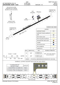
ICAO - , IATA - UOL
Data provided by AirmateGeneral information
Coordinates: N1°6'19" E121°24'56"
Elevation is 12 feet MSL.
View others Airports in Sulawesi Tengah
Operational data
Special qualification required
Current time UTC:
Current local time:
Weather at : - ( 0 km )
METAR: UBBN 131008Z 08010KT 9999 VCTS SCT046CB BKN100 21/08 Q1005 NOSIG
Communications frequencies: [VIEW]
Runways:
| RWY identifier | QFU | Length (ft) | Width (ft) | Surface | LDA (ft) |
| 06 | 63° | 5072 | 98 | UNK | |
| 24 | 243° | 5072 | 98 | UNK |
Airport contact information
Address: Buol Indonesia