


WAAA - Makassar/Sultan Hasanuddin
Located in Makassar, Indonesia
ICAO - WAAA, IATA - UPG
Data provided by AirmateGeneral information
Coordinates: S5°3'39" E119°33'16"
Elevation is 47 feet MSL.
View others Airports in Sulawesi Selatan
Operational data
Special qualification required
Current time UTC:
Current local time:
Weather
METAR: WAAA 272330Z 08005KT 9999 FEW019 26/26 Q1009 NOSIG
TAF: TAF WAAA 272300Z 2800/2906 10005KT 9999 FEW019 BECMG 2802/2803 29010KT TEMPO 2809/2811 FEW018CB
Communications frequencies: [VIEW]
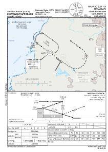
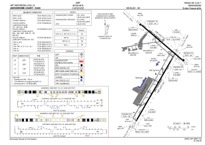
Runways:
| RWY identifier | QFU | Length (ft) | Width (ft) | Surface | LDA (ft) |
| 13 | 131° | 8202 | 148 | ASP | |
| 31 | 311° | 8202 | 148 | ASP | |
| 03 | 30° | 10171 | 148 | UNK | |
| 21 | 210° | 10171 | 148 | UNK |
Airport contact information
Address: Makassar Indonesia