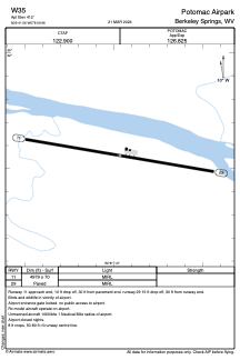


W35 - Potomac Airpark
Located in Berkeley Springs, United States
ICAO - W35, IATA -
Data provided by AirmateGeneral information
Coordinates: N39°41'33" W78°9'58"
Elevation is 413 feet MSL.
Magnetic variation is -10° East View others Airports in West Virginia
Operational data
Special qualification required
Current time UTC:
Current local time:
Weather at : KMRB - Eastern Wv Rgnl/Shepherd Fld ( 36 km )
METAR: KMRB 171353Z 03004KT 10SM OVC020 17/14 A2997 RMK AO2 SLP147 T01670139
TAF: KMRB 171120Z 1712/1812 03003KT P6SM BKN018 FM171500 11004KT P6SM BKN025 FM171800 12005KT P6SM BKN035 FM172200 13005KT P6SM -SHRA VCTS OVC040CB FM180300 14002KT 5SM -SHRA BR OVC015 FM180900 07002KT 4SM -SHRA BR OVC007
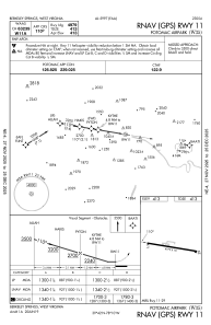
Communications frequencies: [VIEW]
Runways:
| RWY identifier | QFU | Length (ft) | Width (ft) | Surface | LDA (ft) |
| 11 | 100° | 4979 | 70 | ASPH | |
| 29 | 280° | 4979 | 70 | ASPH |
Airport contact information
Address: Berkeley Springs United States