


VYKI - Kanti
Located in Kanti, Myanmar
ICAO - VYKI, IATA - KHM
Data provided by AirmateGeneral information
Coordinates: N25°59'19" E95°40'29"
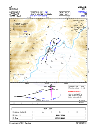
Elevation is 672 feet MSL.
View others Airports in Sagaing Division
Operational data
Special qualification required
Current time UTC:
Current local time:
Weather at : - ( 0 km )
METAR: KSWO 130553Z AUTO 11007KT 7SM VCTS -RA SCT003 BKN048 OVC090 17/17 A2977 RMK AO2 LTG DSNT NE-S TSB10E37 PRESFR SLP073 6//// T01720172 10217 20172 402390128 57013 PNO $
Communications frequencies: [VIEW]
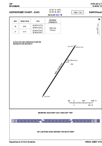
Runways:
| RWY identifier | QFU | Length (ft) | Width (ft) | Surface | LDA (ft) |
| 03 | 35° | 6001 | 98 | UNK | |
| 21 | 215° | 6001 | 98 | UNK |
Airport contact information
Address: Kanti Myanmar