


VYKI - Kanti
Located in Kanti, Myanmar
ICAO - VYKI, IATA - KHM
Data provided by AirmateGeneral information
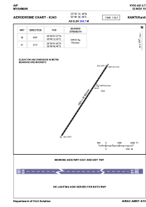
Coordinates: N25°59'19" E95°40'29"
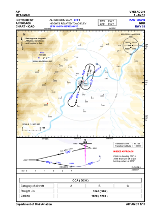
Elevation is 672 feet MSL.
View others Airports in Sagaing Division
Operational data
Special qualification required
Current time UTC:
Current local time:
Weather at : - ( 0 km )
METAR: CYPD 020108Z AUTO 30009G17KT 3/4SM BR OVC002 03/03 A2992 RMK SLP140
Communications frequencies: [VIEW]
Runways:
| RWY identifier | QFU | Length (ft) | Width (ft) | Surface | LDA (ft) |
| 03 | 35° | 6001 | 98 | UNK | |
| 21 | 215° | 6001 | 98 | UNK |
Airport contact information
Address: Kanti Myanmar