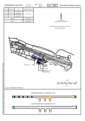


VTCH - Mae Hong Son / Mae Hong Son Airport
Located in Mae Hong Son, Thailand
ICAO - VTCH, IATA - HGN
Data provided by AirmateGeneral information
Coordinates: N19°18'6" E97°58'30"
Elevation is 929 feet MSL.
View others Airports in Mae Hong Son Province
Operational data
Special qualification required
Current time UTC:
Current local time:
Weather
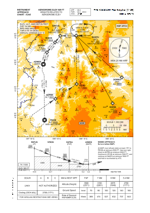
TAF: TAF VTCH 281100Z 2812/2912 26005KT 7000 FEW025 BECMG 2820/2822 4000 HZ BECMG 2904/2906 8000 NSW
Communications frequencies: [VIEW]
Runways:
| RWY identifier | QFU | Length (ft) | Width (ft) | Surface | LDA (ft) |
| 11 | 109° | 6562 | 98 | ASP | |
| 29 | 289° | 6562 | 98 | ASP |
Airport contact information
Address: Mae Hong Son Thailand