


VT8 - Shelburne
Located in Shelburne, United States
ICAO - VT8, IATA -
Data provided by AirmateGeneral information
Coordinates: N44°21'37" W73°13'35"
Elevation is 325 feet MSL.
Magnetic variation is -15° East View others Airports in Vermont
Operational data
Special qualification required
Current time UTC:
Current local time:
Weather at : KBTV - Patrick Leahy Burlington Intl ( 14 km )
TAF: KBTV 141120Z 1412/1512 19010KT P6SM BKN080 OVC100 FM141900 19009KT 3SM -SHRA BR BKN090 FM142100 18007KT P6SM VCSH BKN160 FM150600 VRB03KT P6SM VCSH BKN050 FM150800 00000KT 1SM BR VCSH BKN100
Communications frequencies: [VIEW]
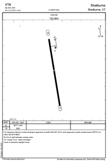
Runways:
| RWY identifier | QFU | Length (ft) | Width (ft) | Surface | LDA (ft) |
| 01 | 351° | 3077 | 60 | GRASS | |
| 19 | 171° | 3077 | 60 | GRASS |
Airport contact information
Address: Shelburne United States
