


VOML - Mangaluru International Airport, Mangaluru
Located in Mangaluru, India
ICAO - VOML, IATA - IXE
Data provided by AirmateGeneral information
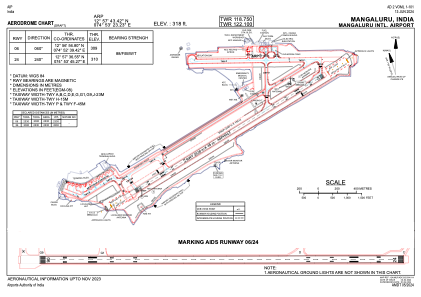
Coordinates: N12°57'43" E74°53'23"
Elevation is 320 feet MSL.
View others Airports in Karnataka
Operational data
Special qualification required
Current time UTC:
Current local time:
Weather
METAR: VOML 151900Z VRB02KT 6000 FEW015 27/23 Q1010 NOSIG
TAF: TAF VOML 151700Z 1518/1624 29010KT 6000 SCT015 BECMG 1520/1521 07005KT BECMG 1606/1607 27010KT TEMPO 1609/1615 3000 TSRA RA SCT012 SCT020 FEW025CB
Communications frequencies: [VIEW]
Runways:
| RWY identifier | QFU | Length (ft) | Width (ft) | Surface | LDA (ft) |
| 06 | 58° | 8038 | 151 | UNK | |
| 24 | 238° | 8038 | 151 | UNK |
Airport contact information
Address: Mangaluru India