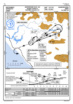
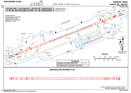


VOKN - Kannur International Airport, Mattannur, Kannur
Located in Mattannur, India
ICAO - , IATA - CNN
Data provided by AirmateGeneral information
Coordinates: N11°54'57" E75°32'45"
Elevation is 344 feet MSL.
View others Airports in Kerala
Operational data
Special qualification required
Current time UTC:
Current local time:
Weather
METAR: VOKN 130200Z 05004KT 4000 TS BR SCT012 FEW025CB BKN080 28/25 Q1010 TEMPO 3000 -TSRA
TAF: TAF VOKN 130200Z 1303/1312 10005KT 4000 BR SCT012 FEW025CB BECMG 1303/1305 1005KT 5000 HZ SCT012 SCT080 TEMPO 1309/1312 28010G20KT 3000 TSRA RA FEW008 SCT012 FEW025CB OVC080
Communications frequencies: [VIEW]
Runways:
| RWY identifier | QFU | Length (ft) | Width (ft) | Surface | LDA (ft) |
| 07 | 69° | 10007 | 148 | UNK | |
| 25 | 249° | 10007 | 148 | UNK |
Airport contact information
Address: Mattannur India