


VETJ - Tezu Airport, Tezu
Located in Tezu, India
ICAO - , IATA - TEI
Data provided by AirmateGeneral information
Coordinates: N27°56'32" E96°8'2"
Elevation is 769 feet MSL.
View others Airports in Arunachal Pradesh
Operational data
Special qualification required
Current time UTC:
Current local time:
Weather at : - ( 0 km )
METAR: SCSN 300752Z AUTO 01005KT 310V060 9999 -RA OVC006 12/12 Q1017 RERA
Communications frequencies: [VIEW]
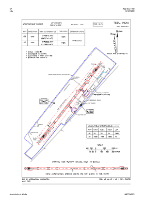
Runways:
| RWY identifier | QFU | Length (ft) | Width (ft) | Surface | LDA (ft) |
| 04 | 40° | 4921 | 98 | UNK | |
| 22 | 220° | 4921 | 98 | UNK |
Airport contact information
Address: Tezu India