


UTDT - Bokhtar
Located in Bokhtar, Tajikistan
ICAO - UTDT, IATA - KQT
Data provided by AirmateGeneral information
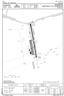
Coordinates: N37°52'2" E68°51'52"
Elevation is 1479 feet MSL.
View others Airports in Khatlon Province
Operational data
Special qualification required
Current time UTC:
Current local time:
Weather
METAR: UTDT 091230Z 20006MPS 1600 HZ FEW006 SCT016 BKN100 29/14 Q1007 R35/CLRD70 RMK QBB200 QFE716/0955
TAF: TAF UTDT 091207Z 0913/1001 19005MPS 1400 HZ SCT011 BKN030CB OVC060 TEMPO 0913/1001 21007G13MPS 2100 -TSRA HZ
Communications frequencies: [VIEW]
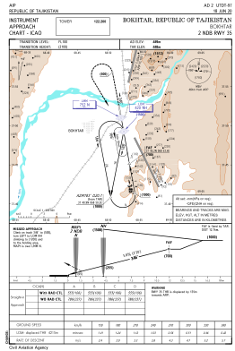
Runways:
| RWY identifier | QFU | Length (ft) | Width (ft) | Surface | LDA (ft) |
| 17 | 170° | 8038 | 138 | UNK | |
| 35 | 350° | 8038 | 138 | UNK |
Airport contact information
Address: Bokhtar Tajikistan