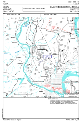
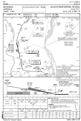
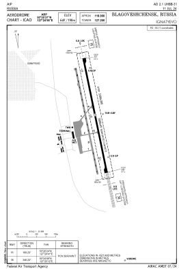


UHBB - Blagoveshchensk/Ignatyevo
Located in Blagoveshchensk, Russian Federation
ICAO - UHBB, IATA - BQS
Data provided by AirmateGeneral information
Coordinates: N50°25'37" E127°24'56"
Elevation is 648 feet MSL.
View others Airports in Amur Oblast
Operational data
Special qualification required
Current time UTC:
Current local time:
Weather
METAR: UHBB 050100Z 36006G11MPS 340V040 9999 FEW033 11/03 Q1015 R36R/090067 NOSIG RMK QFE744/0992
TAF: TAF UHBB 042235Z 0500/0524 01006G12MPS 9999 SCT033CB BECMG 0508/0511 34003MPS
Communications frequencies: [VIEW]
Runways:
| RWY identifier | QFU | Length (ft) | Width (ft) | Surface | LDA (ft) |
| 18L | 168° | 9843 | 148 | UNK | |
| 36R | 348° | 9843 | 148 | UNK | |
| 18R | 168° | 9186 | 148 | UNK | |
| 36L | 348° | 9186 | 148 | UNK |
Airport contact information
Address: Blagoveshchensk Russian Federation