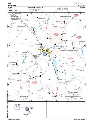
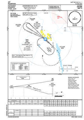
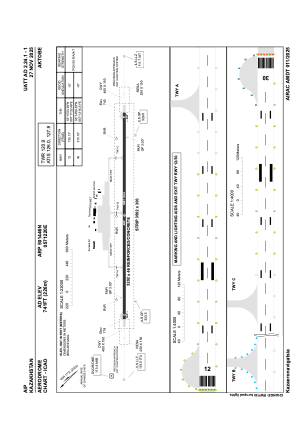


UATT - Aktobe
Located in Aktobe, Kazakhstan
ICAO - UATT, IATA - AKX
Data provided by AirmateGeneral information
Coordinates: N50°14'46" E57°12'20"
Elevation is 741 feet MSL.
Magnetic variation is 11° East View others Airports in Aktobe
Operational data
Special qualification required
Current time UTC:
Current local time:
Weather
METAR: UATT 120200Z 14004MPS 9999 -SHRA SCT057CB 11/08 Q1011 NOSIG RMK QFE738/0985
TAF: TAF UATT 112301Z 1200/1224 16005MPS 9999 BKN033 TX22/1210Z TN06/1201Z TEMPO 1200/1206 17010MPS 3100 -TSRA BKN020CB TEMPO 1206/1214 18012MPS 3100 -SHRA BKN030CB FM121400 19005MPS 3100 -SHRA BR BKN011 BKN030CB
Communications frequencies: [VIEW]
Runways:
| RWY identifier | QFU | Length (ft) | Width (ft) | Surface | LDA (ft) |
| 12 | 135° | 10505 | 151 | CONC | 10505 |
| 30 | 315° | 10505 | 151 | CONC | 10505 |
Airport contact information
Address: Aktobe Kazakhstan