


U48 - Coxs Well
Located in Atomic City, United States
ICAO - U48, IATA -
Data provided by AirmateGeneral information
Coordinates: N43°13'4" W113°13'39"
Elevation is 5048 feet MSL.
Magnetic variation is 16° East View others Airports in Idaho
Operational data
Special qualification required
Current time UTC:
Current local time:
Weather at : KPIH - Pocatello Rgnl ( 62 km )
METAR: KPIH 161953Z 21014G28KT 10SM CLR 23/06 A2994 RMK AO2 PK WND 23028/1944 SLP101 T02280056
TAF: KPIH 161732Z 1618/1718 25015G25KT P6SM SCT200 FM170200 21012KT P6SM FEW150 FM171200 23025G40KT P6SM FEW150
Communications frequencies: [VIEW]
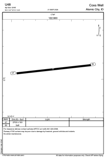
Runways:
| RWY identifier | QFU | Length (ft) | Width (ft) | Surface | LDA (ft) |
| 07 | 83° | 2700 | 100 | GRASS | |
| 25 | 263° | 2700 | 100 | GRASS |
Airport contact information
Address: Atomic City United States