


U34 - Green River Muni
Located in Green River, United States
ICAO - U34, IATA -
Data provided by AirmateGeneral information
Coordinates: N38°57'42" W110°13'38"
Elevation is 4234 feet MSL.
Magnetic variation is 14° East View others Airports in Utah
Operational data
Special qualification required
Current time UTC:
Current local time:
Weather at : KCNY - Canyonlands Rgnl ( 47 km )
METAR: KCNY 281353Z AUTO 00000KT 10SM BKN065 OVC080 09/07 A2995 RMK AO2 SLP125 T00890072
TAF: KCNY 281120Z 2812/2912 30002KT P6SM BKN120 FM282000 30008KT P6SM FEW070 FEW130 FM290000 31012KT P6SM FEW090 FEW250 FM290500 29007KT P6SM SKC FM291000 00000KT P6SM SKC
Communications frequencies: [VIEW]
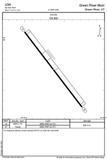
Runways:
| RWY identifier | QFU | Length (ft) | Width (ft) | Surface | LDA (ft) |
| 13 | 142° | 5600 | 75 | ASPH | |
| 31 | 322° | 5600 | 75 | ASPH |
Airport contact information
Address: Green River United States