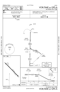
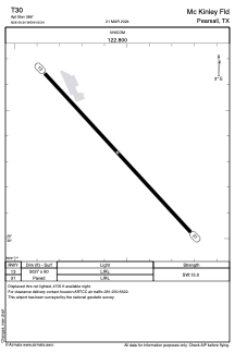


T30 - Mc Kinley Fld
Located in Pearsall, United States
ICAO - T30, IATA -
Data provided by AirmateGeneral information
Coordinates: N28°49'20" W99°6'33"
Elevation is 586 feet MSL.
Magnetic variation is 07° East View others Airports in Texas
Operational data
Special qualification required
Current time UTC:
Current local time:
Weather at : KCOT - Cotulla-La Salle County ( 42 km )
METAR: KCOT 150353Z AUTO 13008KT 10SM CLR 28/17 A2982 RMK AO2 SLP091 T02780167
TAF: KCOT 142327Z 1500/1524 13011KT P6SM SKC FM151600 15011G18KT P6SM FEW250 FM152200 12017G27KT P6SM FEW250
Communications frequencies: [VIEW]
Runways:
| RWY identifier | QFU | Length (ft) | Width (ft) | Surface | LDA (ft) |
| 13 | 137° | 5027 | 60 | ASPH | |
| 31 | 317° | 5027 | 60 | ASPH |
Airport contact information
Address: Pearsall United States