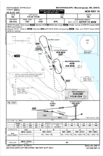
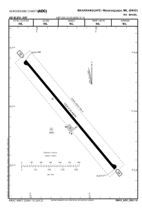


SNXX - Maxaranguape
Located in Maxaranguape, Brazil
ICAO - SNXX, IATA -
Data provided by AirmateGeneral information
Coordinates: S5°22'55" W35°31'51"
Elevation is 304 feet MSL.
Magnetic variation is -20.767281444° East View others Airports in Rio Grande do Norte
Operational data
Special qualification required
Current time UTC:
Current local time:
Weather at : SBSG - São Gonçalo Do Amarante - Governador Aluizio Alves ( 47 km )
METAR: SBSG 132000Z 11005KT 9999 -RA SCT033 29/24 Q1012
TAF: TAF SBSG 132005Z 1400/1424 12010KT 9999 FEW025 TN25/1409Z TX30/1415Z BECMG 1402/1404 20005KT BECMG 1406/1408 SCT010 BKN017 BECMG 1410/1412 16005KT BECMG 1414/1416 12010KT BKN025 BECMG 1421/1423 15005KT FEW020 RMK PFV
Communications frequencies: [VIEW]
Runways:
| RWY identifier | QFU | Length (ft) | Width (ft) | Surface | LDA (ft) |
| 16 | 0° | 7218 | 98 | ASPH | |
| 34 | 0° | 7218 | 98 | ASPH |
Airport contact information
Address: Maxaranguape Brazil