


SN29 - Alves E Moura Heliport
Located in Bezerros, United States
ICAO - SN29, IATA -
Data provided by AirmateGeneral information
Coordinates: S8°11'12" W35°46'56"
Elevation is 2151 feet MSL.
Magnetic variation is -21.683333333° East View others Airports in Kansas
Operational data
Special qualification required
Current time UTC:
Current local time:
Weather at : - ( 0 km )
METAR: PAMD 021751Z AUTO 11019G28KT 10SM SCT018 OVC027 07/04 A3000 RMK AO2 PK WND 11029/1715 SLP145 T00670039 10072 20061 56003
Communications frequencies: [VIEW]
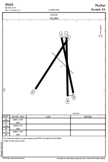
Runways:
| RWY identifier | QFU | Length (ft) | Width (ft) | Surface | LDA (ft) |
| 03 | 33° | 2361 | 100 | GRASS | |
| 21 | 213° | 2361 | 100 | GRASS | |
| 16 | 169° | 66 | 66 | CONC | |
| 34 | 349° | 66 | 66 | CONC | |
| 17 | 179° | 2460 | 100 | GRASS | |
| 35 | 359° | 2460 | 100 | GRASS |
Airport contact information
Address: Bezerros United States