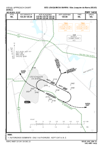


SDJO - Sao Joaquim Da Barra
Located in Sao Joaquim Da Barra, Brazil
ICAO - SDJO, IATA -
Data provided by AirmateGeneral information
Coordinates: S20°35'36" W47°50'32"
Elevation is 2133 feet MSL.
Magnetic variation is -21.624912568° East View others Airports in São Paulo
Operational data
Special qualification required
Current time UTC:
Current local time:
Weather at : SBRP - Leite Lopes ( 61 km )
METAR: SBRP 291200Z 10005KT 070V140 CAVOK 25/18 Q1018
TAF: TAF SBRP 290845Z 2912/2924 10006KT 9999 FEW025 TX33/2918Z TN24/2924Z BECMG 2914/2916 36005KT BECMG 2919/2921 32004KT BECMG 2922/2924 10005KT RMK PGM
Communications frequencies: [VIEW]
Runways:
| RWY identifier | QFU | Length (ft) | Width (ft) | Surface | LDA (ft) |
| 14 | 0° | 3281 | 98 | EARTH | |
| 32 | 0° | 3281 | 98 | EARTH |
Airport contact information
Address: Sao Joaquim Da Barra Brazil