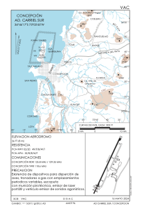
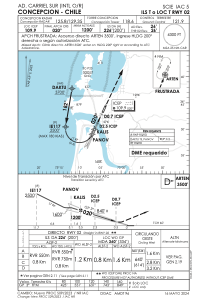
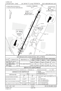


SCIE - Carriel Sur
Located in Concepcion, Chile
ICAO - SCIE, IATA - CCP
Data provided by AirmateGeneral information
Coordinates: S36°46'17" W73°3'45"
Elevation is 26 feet MSL.
Magnetic variation is 5° East View others Airports in Bío-Bío
Operational data
Special qualification required
Current time UTC:
Current local time:
Weather
METAR: SCIE 051000Z 00000KT 9999 BKN040 09/09 Q1017
TAF: TAF SCIE 050400Z 0506/0606 01010KT 7000 -RA SCT020 BKN030 TX14/0518Z TN09/0510Z BECMG 0508/0510 8000 -SHRA FEW030 BKN050 BECMG 0515/0517 31010KT 9999 NSW BKN050 TEMPO 0601/0606 01010KT 8000 -SHRA SCT020 BKN050
Communications frequencies: [VIEW]
Runways:
| RWY identifier | QFU | Length (ft) | Width (ft) | Surface | LDA (ft) |
| 02 | 25° | 8530 | 148 | ASPH | 8530 |
| 20 | 205° | 8530 | 148 | ASPH | 8530 |
Airport contact information
Address: Concepcion Chile
