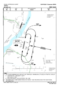


SBOI - Oiapoque
Located in Oiapoque, Brazil
ICAO - SBOI, IATA - OYK
Data provided by AirmateGeneral information
Coordinates: N3°51'41" W51°47'46"
Elevation is 53 feet MSL.
Magnetic variation is -19° East View others Airports in Amapá
Operational data
Special qualification required
Current time UTC:
Current local time:
Weather
METAR: SBOI 280800Z AUTO VRB02KT 9999 // BKN020/// BKN026/// BKN046/// 24/24 Q1010
TAF: TAF SBOI 280300Z 2806/2818 02005KT 9999 BKN025 TN23/2807Z TX30/2816Z PROB30 2806/2809 BKN005 BECMG 2816/2818 06005KT SCT025 RMK PHD
Communications frequencies: [VIEW]
Runways:
| RWY identifier | QFU | Length (ft) | Width (ft) | Surface | LDA (ft) |
| 21 | 0° | 4921 | 98 | ASPH | |
| 03 | 0° | 4921 | 98 | ASPH |
Airport contact information
Address: Oiapoque Brazil