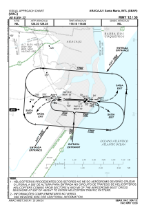
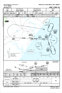


SBAR - Aracaju / Santa Maria
Located in Aracaju, Brazil
ICAO - SBAR, IATA - AJU
Data provided by AirmateGeneral information
Coordinates: S10°59'7" W37°4'24"
Elevation is 23 feet MSL.
Magnetic variation is -23.0° East View others Airports in Sergipe
Operational data
Special qualification required
Current time UTC:
Current local time:
Weather
METAR: SBAR 281200Z 16009KT 9999 VCSH FEW024 FEW026TCU SCT080 29/23 Q1013
TAF: TAF SBAR 280800Z 2812/2912 12010KT 8000 SCT017 FEW025TCU TX31/2816Z TN25/2908Z BECMG 2818/2820 4500 SHRA TEMPO 2906/2911 30005KT 5000 RA RMK PGU
Communications frequencies: [VIEW]
Runways:
| RWY identifier | QFU | Length (ft) | Width (ft) | Surface | LDA (ft) |
| 12 | 92° | 2320 | 280 | ASPH | |
| 30 | 272° | 2320 | 280 | ASPH |
Airport contact information
Address: Aracaju Brazil
