


S75 - Payette Muni
Located in Payette, United States
ICAO - S75, IATA -
Data provided by AirmateGeneral information
Coordinates: N44°5'38" W116°54'11"
Elevation is 2230 feet MSL.
Magnetic variation is 17° East View others Airports in Idaho
Operational data
Special qualification required
Current time UTC:
Current local time:
Weather at : KONO - Ontario Muni ( 12 km )
METAR: KONO 162353Z AUTO 05005KT 10SM CLR 31/07 A2974 RMK AO2 SLP058 T03110067 10322 20239 56023
TAF: KONO 162324Z 1700/1724 VRB06KT P6SM SCT080 FM170100 34010G18KT P6SM SKC FM170500 31013KT P6SM SKC FM171400 30018G28KT P6SM FEW100
Communications frequencies: [VIEW]
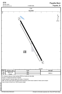
Runways:
| RWY identifier | QFU | Length (ft) | Width (ft) | Surface | LDA (ft) |
| 13 | 0° | 3534 | 45 | ASPH | |
| 31 | 0° | 3534 | 45 | ASPH |
Airport contact information
Address: Payette United States