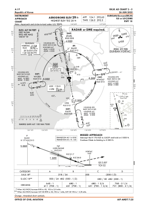
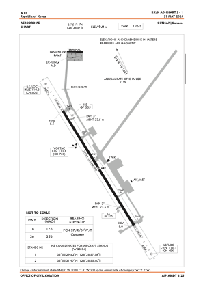


RKJK - Gunsan / Domestic
Located in Gunsan, Korea, Republic of
ICAO - RKJK, IATA - KUV
Data provided by AirmateGeneral information
Coordinates: N35°54'14" E126°36'57"
Elevation is 30 feet MSL.
Magnetic variation is -8° East View others Airports in Jeonrabugdo
Operational data
Special qualification required
Current time UTC:
Current local time:
Weather
METAR: RKJK 172355Z AUTO 12006KT 10SM CLR 22/15 A3004 RMK AO2 SLP177 T02170146 10223 20144 52009 $
TAF: TAF RKJK 180000Z 1800/1906 14006KT 9999 SCT070 QNH3004INS BECMG 1805/1806 27010G15KT 9999 SKC QNH3003INS BECMG 1814/1815 VRB06KT 9000 HZ SKC QNH3000INS BECMG 1822/1823 VRB06KT 9999 NSNW SKC QNH3004INS TX27/1806Z TN15/1821Z
Communications frequencies: [VIEW]
Runways:
| RWY identifier | QFU | Length (ft) | Width (ft) | Surface | LDA (ft) |
| 18 | 169° | 9008 | 150 | CON | |
| 36 | 349° | 9008 | 150 | CON |
Airport contact information
Address: Gunsan Korea, Republic of