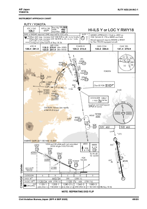
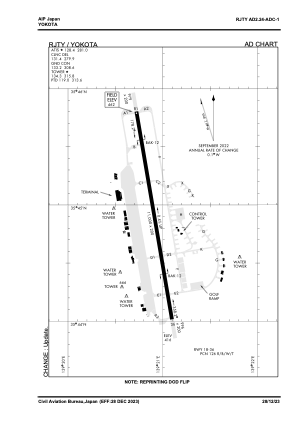


RJTY - Yokota
Located in Tachikawa, Japan
ICAO - RJTY, IATA - OKO
Data provided by AirmateGeneral information
Coordinates: N35°44'55" E139°20'55"
Elevation is 462 feet MSL.
View others Airports in Tokyo Prefecture
Operational data
Special qualification required
Current time UTC:
Current local time:
Weather
TAF: TAF RJTY 180500Z 1805/1911 14009KT 9999 SKC QNH3007INS BECMG 1815/1816 33006KT 9999 FEW030 QNH3012INS BECMG 1822/1823 VRB06KT 9999 FEW030 SCT060 QNH3011INS BECMG 1903/1904 18009KT 9999 SCT030 BKN040 QNH3009INS TX29/1805Z TN17/1820Z
Communications frequencies: [VIEW]
Runways:
| RWY identifier | QFU | Length (ft) | Width (ft) | Surface | LDA (ft) |
| 18 | 170° | 11000 | 200 | CON | |
| 36 | 350° | 11000 | 200 | CON |
Airport contact information
Address: Tachikawa Japan