


RJOB - Okayama
Located in Okayama, Japan
ICAO - RJOB, IATA - OKJ
Data provided by AirmateGeneral information
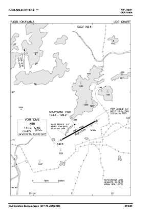
Coordinates: N34°45'25" E133°51'19"
Elevation is 785 feet MSL.
View others Airports in Okayama Prefecture
Operational data
Special qualification required
Current time UTC:
Current local time:
Weather
METAR: RJOB 062300Z 27005KT 9999 FEW020 SCT035 18/14 Q1010
TAF: TAF RJOB 061708Z 0618/0800 13004KT 3000 -SHRA BR BCFG FEW000 SCT005 BKN008 TEMPO 0618/0619 0700 -SHRA FG FEW000 SCT001 BKN003 BECMG 0619/0621 25010KT 9999 NSW FEW020 BKN030 BECMG 0721/0800 35005KT
Communications frequencies: [VIEW]
Runways:
| RWY identifier | QFU | Length (ft) | Width (ft) | Surface | LDA (ft) |
| 07 | 59° | 9843 | 148 | ASP | |
| 25 | 239° | 9843 | 148 | ASP |
Airport contact information
Address: Okayama Japan