


PHLI - Lihue
Located in Lihue,
ICAO - LIH, IATA - LIH
Data provided by AirmateGeneral information
Coordinates: N21°58'34" W159°20'20"
Elevation is 152 feet MSL.
Magnetic variation is 11° East View others Airports in Hawaii
Operational data
Special qualification required
Current time UTC:
Current local time:
Weather
METAR: PHLI 281553Z 10005KT 10SM BKN044 23/21 A3004 RMK AO2 SLP169 T02280206 $
TAF: PHLI 281137Z 2812/2912 10012KT P6SM VCSH SCT015 BKN025 OVC040 FM281600 09009KT P6SM VCSH SCT020 BKN040 FM282000 10010KT P6SM VCSH SCT020 BKN040
Communications frequencies: [VIEW]
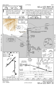
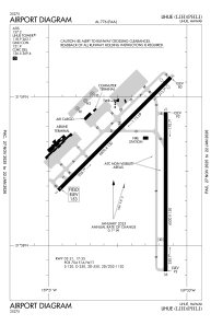
Runways:
| RWY identifier | QFU | Length (ft) | Width (ft) | Surface | LDA (ft) |
| 03 | 45° | 6500 | 150 | ASPH | 6500 |
| 21 | 225° | 6500 | 150 | ASPH | 6295 |
| 17 | 180° | 6500 | 150 | ASPH | 6500 |
| 35 | 0° | 6500 | 150 | ASPH | 6500 |
Airport contact information
Address: Lihue
