


PHKO - Ellison Onizuka Kona Intl At Keahole
Located in Kailua/Kona,
ICAO - KOA, IATA - KOA
Data provided by AirmateGeneral information
Coordinates: N19°44'20" W156°2'44"
Elevation is 48 feet MSL.
Magnetic variation is 11° East View others Airports in Hawaii
Operational data
Special qualification required
Current time UTC:
Current local time:
Weather
METAR: PHKO 271453Z AUTO 11008KT 10SM OVC060 23/19 A3003 RMK AO2 SLP169 60000 T02330194 58002
TAF: PHKO 271136Z 2712/2812 01006KT P6SM SCT025 BKN050 FM272000 24009KT P6SM SCT030 SCT050 FM280500 14006KT P6SM SCT025 BKN060
Communications frequencies: [VIEW]
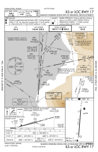
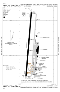
Runways:
| RWY identifier | QFU | Length (ft) | Width (ft) | Surface | LDA (ft) |
| 17 | 185° | 11000 | 150 | ASPH | 11000 |
| 35 | 5° | 11000 | 150 | ASPH | 11000 |
Airport contact information
Address: Kailua/Kona
Other aviation service providers
Flight schools

Mauna Loa Helicopters | Hawaii Pacific Aviation
Mauna Loa Helicopters | Hawaii Pacific Aviation
info@maunaloahelicopters.com8083340234