


PHDH - Dillingham Airfield
Located in Mokuleia,
ICAO - HDH, IATA - HDH
Data provided by AirmateGeneral information
Coordinates: N21°34'46" W158°11'50"
Elevation is 14 feet MSL.
Magnetic variation is 11° East View others Airports in Hawaii
Operational data
Special qualification required
Current time UTC:
Current local time:
Weather at : PHHI - Wheeler Aaf ( 20 km )
METAR: PHHI 281105Z AUTO 18003KT 10SM BKN018 BKN036 BKN060 21/19 A3008 RMK AO2 CIG 018V036 SLP177 $
Communications frequencies: [VIEW]
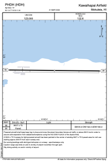
Runways:
| RWY identifier | QFU | Length (ft) | Width (ft) | Surface | LDA (ft) |
| 08 | 91° | 9007 | 75 | ASPH | |
| 26 | 271° | 9007 | 75 | ASPH |
Airport contact information
Address: Mokuleia
