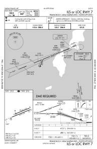
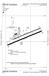


PGSN - Francisco C Ada/Saipan Intl
Located in Saipan Island, Northern Mariana Islands
ICAO - GSN, IATA - SPN
Data provided by AirmateGeneral information
Coordinates: N15°7'13" E145°43'48"
Elevation is 214 feet MSL.
Magnetic variation is 02° East View others Airports in (unassigned)
Operational data
Special qualification required
Current time UTC:
Current local time:
Weather
METAR: PGSN 151754Z 09011KT 10SM FEW017 SCT022 28/24 A2989 RMK AO2 SLP140 60004 T02780244 10289 20272 55006
TAF: PGSN 151720Z 1518/1618 09015KT P6SM VCSH FEW020 SCT050
Communications frequencies: [VIEW]
Runways:
| RWY identifier | QFU | Length (ft) | Width (ft) | Surface | LDA (ft) |
| 06 | 68° | 7001 | 100 | ASPH | 6600 |
| 24 | 248° | 7001 | 100 | ASPH | 7000 |
| 07 | 68° | 8699 | 200 | ASPH | 8010 |
| 25 | 248° | 8699 | 200 | ASPH | 8010 |
Airport contact information
Address: Saipan Island Northern Mariana Islands