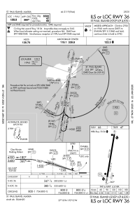
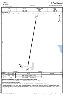


PASN - St Paul Island
Located in St Paul Island,
ICAO - SNP, IATA - SNP
Data provided by AirmateGeneral information
Coordinates: N57°9'59" W170°13'21"
Elevation is 66 feet MSL.
Magnetic variation is 10° East View others Airports in Alaska
Operational data
Special qualification required
Current time UTC:
Current local time:
Weather
METAR: PASN 272153Z AUTO 34005KT 10SM OVC005 01/01 A2998 RMK AO2 SLP153 T00110006 TSNO $
TAF: PASN 271722Z 2718/2818 34008KT 3SM BR OVC004 TEMPO 2718/2721 1/2SM FG VV003 FM272100 36008KT 6SM BR OVC006 FM280200 34006KT P6SM SCT015 OVC025
Communications frequencies: [VIEW]
Runways:
| RWY identifier | QFU | Length (ft) | Width (ft) | Surface | LDA (ft) |
| 18 | 190° | 6500 | 150 | ASPH | |
| 36 | 10° | 6500 | 150 | ASPH |
Airport contact information
Address: St Paul Island