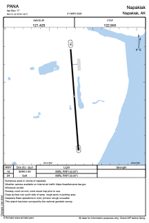


PANA - Napakiak
Located in Napakiak,
ICAO - WNA, IATA - WNA
Data provided by AirmateGeneral information
Coordinates: N60°41'25" W161°58'43"
Elevation is 17 feet MSL.
Magnetic variation is 14° East View others Airports in Alaska
Operational data
Special qualification required
Current time UTC:
Current local time:
Weather
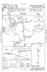
METAR: PANA 271556Z AUTO 02008KT 10SM OVC110 01/M01 A2977 RMK AO2 SLP079 T00111006 FZRANO TSNO
Communications frequencies: [VIEW]
Runways:
| RWY identifier | QFU | Length (ft) | Width (ft) | Surface | LDA (ft) |
| 16 | 176° | 3248 | 60 | GRAVEL | |
| 34 | 356° | 3248 | 60 | GRAVEL |
Airport contact information
Address: Napakiak