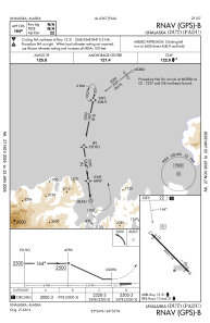
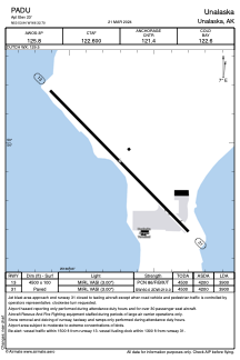


PADU - Unalaska
Located in Unalaska,
ICAO - DUT, IATA - DUT
Data provided by AirmateGeneral information
Coordinates: N53°53'56" W166°32'42"
Elevation is 23 feet MSL.
Magnetic variation is 09° East View others Airports in Alaska
Operational data
Special qualification required
Current time UTC:
Current local time:
Weather
METAR: PADU 061727Z 26004KT 10SM SCT021 SCT030 OVC039 01/M02 A2974 RMK AO2 RAB10E19UPB19E21 P0000
TAF: PADU 061737Z 0618/0718 31011KT P6SM VCSH BKN030 OVC040 TEMPO 0618/0622 6SM -RA SCT015 BKN025 FM062200 34013KT P6SM VCSH SCT015 OVC030
Communications frequencies: [VIEW]
Runways:
| RWY identifier | QFU | Length (ft) | Width (ft) | Surface | LDA (ft) |
| 13 | 136° | 4500 | 100 | ASPH | 3900 |
| 31 | 316° | 4500 | 100 | ASPH | 3900 |
Airport contact information
Address: Unalaska