


OH71 - Troy Skypark
Located in Troy, United States
ICAO - OH71, IATA -
Data provided by AirmateGeneral information
Coordinates: N39°59'26" W84°16'15"
Elevation is 930 feet MSL.
Magnetic variation is -04° East View others Airports in Ohio
Operational data
Special qualification required
Current time UTC:
Current local time:
Weather at : KDAY - James M Cox Dayton Intl ( 11 km )
METAR: KDAY 142356Z 13006KT 10SM -RA SCT017 BKN026 OVC100 18/17 A2974 RMK AO2 SLP067 P0000 60017 T01780172 10194 20178 53000
TAF: KDAY 142336Z 1500/1524 12007KT P6SM VCSH SCT008 BKN018 FM150700 09005KT P6SM -SHRA VCTS OVC016CB FM151400 04008KT P6SM VCSH OVC011 FM151700 03009KT P6SM VCTS BKN018CB FM152200 02011KT P6SM SCT022 BKN035
Communications frequencies: [VIEW]
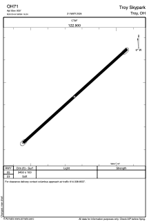
Runways:
| RWY identifier | QFU | Length (ft) | Width (ft) | Surface | LDA (ft) |
| 05 | 48° | 3450 | 100 | GRASS | |
| 23 | 228° | 3450 | 100 | GRASS |
Airport contact information
Address: Troy United States