


O45 - Hooker Muni
Located in Hooker, United States
ICAO - O45, IATA -
Data provided by AirmateGeneral information
Coordinates: N36°51'25" W101°13'38"
Elevation is 3000 feet MSL.
Magnetic variation is 09° East View others Airports in Oklahoma
Operational data
Special qualification required
Current time UTC:
Current local time:
Weather at : KGUY - Guymon Muni ( 31 km )
METAR: KGUY 090553Z AUTO 06009KT 10SM CLR 13/M01 A2986 RMK AO2 SLP077 T01331011 10233 20128 402500061 51027
TAF: KGUY 090525Z 0906/1006 04010KT P6SM BKN200 FM091800 04010G20KT P6SM SCT200 FM100200 03010KT P6SM BKN250
Communications frequencies: [VIEW]
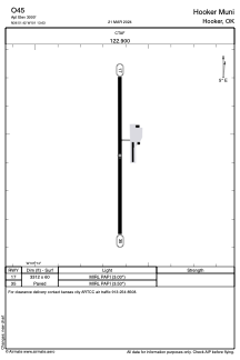
Runways:
| RWY identifier | QFU | Length (ft) | Width (ft) | Surface | LDA (ft) |
| 17 | 180° | 3312 | 60 | ASPH | |
| 35 | 360° | 3312 | 60 | ASPH |
Airport contact information
Address: Hooker United States