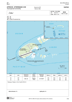


NTUV - Vahitahi
Located in Mohitu, French Polynesia
ICAO - NTUV, IATA - VHZ
Data provided by AirmateGeneral information
Coordinates: S18°46'47" W138°51'11"
Elevation is 11 feet MSL.
Magnetic variation is 13.15° East View others Airports in (unassigned)
Operational data
Special qualification required
Current time UTC:
Current local time:
Weather at : - ( 0 km )
METAR: PALP 012047Z 25006KT 10SM SCT040 M14/M17 A3056
Communications frequencies: [VIEW]
Runways:
| RWY identifier | QFU | Length (ft) | Width (ft) | Surface | LDA (ft) |
| 06 | 70° | 3117 | 82 | ASPH | 2953 |
| 24 | 250° | 3117 | 82 | ASPH | 2953 |
Airport contact information
Address: Mohitu French Polynesia