


NE67 - Falk Air Fld
Located in Hoskins, United States
ICAO - NE67, IATA -
Data provided by AirmateGeneral information
Coordinates: N42°6'28" W97°20'29"
Elevation is 1710 feet MSL.
View others Airports in Nebraska
Operational data
Special qualification required
Current time UTC:
Current local time:
Weather at : KOFK - Norfolk Rgnl/Karl Stefan Meml Fld ( 16 km )
METAR: KOFK 100556Z AUTO 27007KT 10SM CLR 12/07 A3008 RMK AO2 SLP186 T01170072 10211 20106 402280072 51007
TAF: KOFK 100520Z 1006/1106 30007KT P6SM BKN100 FM101700 32013G20KT P6SM SCT060 BKN080 FM110000 31009KT P6SM SCT100
Communications frequencies: [VIEW]
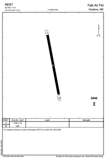
Runways:
| RWY identifier | QFU | Length (ft) | Width (ft) | Surface | LDA (ft) |
| 17 | 170° | 1795 | 75 | GRASS | |
| 35 | 350° | 1795 | 75 | GRASS |
Airport contact information
Address: Hoskins United States