


MO2 - Flying Bar H Ranch
Located in Springfield, United States
ICAO - MO2, IATA -
Data provided by AirmateGeneral information
Coordinates: N37°10'31" W93°7'44"
Elevation is 1380 feet MSL.
Magnetic variation is 04° East View others Airports in Missouri
Operational data
Special qualification required
Current time UTC:
Current local time:
Weather at : KSGF - Springfield-Branson Ntl ( 24 km )
METAR: KSGF 210252Z AUTO 15007KT 10SM CLR 24/19 A2983 RMK AO2 SLP088 T02390189 $
TAF: KSGF 202320Z 2100/2124 16010KT P6SM FEW050 FM210900 16012KT P6SM SKC WS020/20040KT FM211200 16014G18KT P6SM SKC FM211800 19020G28KT P6SM SCT050 BKN250
Communications frequencies: [VIEW]
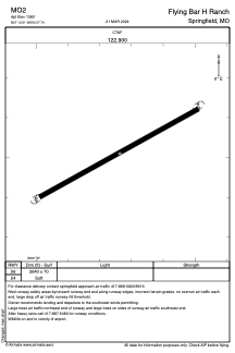
Runways:
| RWY identifier | QFU | Length (ft) | Width (ft) | Surface | LDA (ft) |
| 06 | 0° | 2640 | 70 | GRASS | |
| 24 | 0° | 2640 | 70 | GRASS |
Airport contact information
Address: Springfield United States