


MO00 - Turkey Mountain
Located in Shell Knob, United States
ICAO - MO00, IATA -
Data provided by AirmateGeneral information
Coordinates: N36°35'32" W93°39'50"
Elevation is 1070 feet MSL.
Magnetic variation is 04° East View others Airports in Missouri
Operational data
Special qualification required
Current time UTC:
Current local time:
Weather at : KFWB - Branson West Muni - Emerson Fld ( 26 km )
METAR: KFWB 140735Z AUTO 00000KT M1/4SM FG VV000 14/14 A2968 RMK AO2
Communications frequencies: [VIEW]
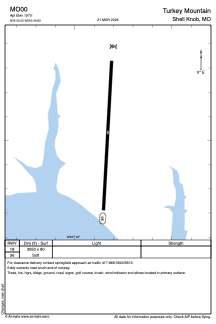
Runways:
| RWY identifier | QFU | Length (ft) | Width (ft) | Surface | LDA (ft) |
| 18 | 0° | 3950 | 80 | GRASS | |
| 36 | 0° | 3950 | 80 | GRASS |
Airport contact information
Address: Shell Knob United States