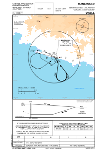
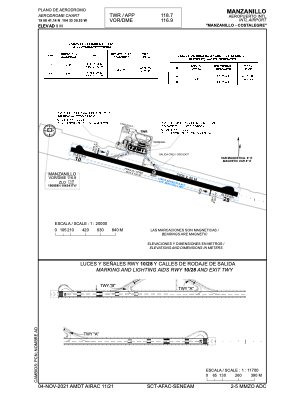


MMZO - Manzanillo Aeropuerto Internacional Costalegre
Located in Manzanillo, Mexico
ICAO - MMZO, IATA - ZLO
Data provided by AirmateGeneral information
Coordinates: N19°8'41" W104°33'31"
Elevation is 30 feet MSL.
View others Airports in Col ima
Operational data
Special qualification required
Current time UTC:
Current local time:
Weather
METAR: MMZO 022245Z 27022KT 12SM SCT200 26/22 A2972 RMK 8/001 HZY
TAF: TAF MMZO 021651Z 0218/0318 24015KT P6SM SCT250 FM030300 00000KT P6SM SKC FM031200 00000KT P6SM SCT020
Communications frequencies: [VIEW]
Runways:
| RWY identifier | QFU | Length (ft) | Width (ft) | Surface | LDA (ft) |
| 10 | 106° | 7238 | 148 | ASP | |
| 28 | 286° | 7238 | 148 | ASP |
Airport contact information
Address: Manzanillo Mexico