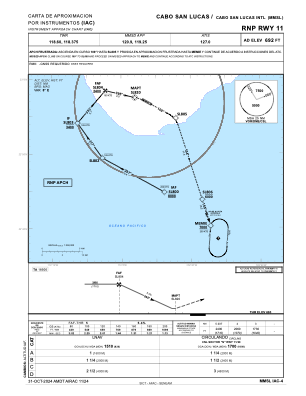
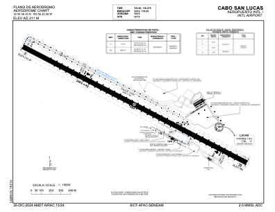


MMSL - Cabo San Lucas Aeropuerto Internacional
Located in Cabo San Lucas, Mexico
ICAO - MMSL, IATA -
Data provided by AirmateGeneral information
Coordinates: N22°56'54" W109°56'18"
Elevation is 692 feet MSL.
View others Airports in Baja California Sur
Operational data
Special qualification required
Current time UTC:
Current local time:
Weather
METAR: MMSL 151318Z RTD 27013KT 8SM FEW240 23/03 A2984 RMK 8/001 RTS
TAF: TAF MMSL 150454Z 1506/1606 30005KT P6SM SKC FM151700 24015KT P6SM SCT200 BECMG 1523/1601 BKN200 FM160400 30010KT P6SM SCT200
Communications frequencies: [VIEW]
Runways:
| RWY identifier | QFU | Length (ft) | Width (ft) | Surface | LDA (ft) |
| 11 | 119° | 6998 | 148 | ASP | |
| 29 | 299° | 6998 | 148 | ASP |
Airport contact information
Address: Cabo San Lucas Mexico