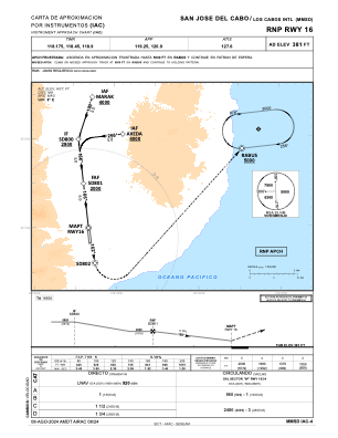
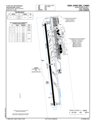


MMSD - San Jose Del Cabo Aeropuerto Internacional Los Cabos
Located in San Jose Del Cabo, Mexico
ICAO - MMSD, IATA - SJD
Data provided by AirmateGeneral information
Coordinates: N23°9'7" W109°43'15"
Elevation is 381 feet MSL.
View others Airports in Baja California Sur
Operational data
Special qualification required
Current time UTC:
Current local time:
Weather
METAR: MMSD 220244Z 22003KT 10SM SCT250 29/07 A2982 RMK SLP081 52017 951 8/004
TAF: TAF MMSD 211655Z 2118/2218 18010KT P6SM SKC FM212100 16016KT P6SM SCT200 FM220100 31010KT P6SM SCT200 FM221200 05005KT P6SM SKC
Communications frequencies: [VIEW]
Runways:
| RWY identifier | QFU | Length (ft) | Width (ft) | Surface | LDA (ft) |
| 16 | 173° | 9856 | 148 | ASP | |
| 34 | 353° | 9856 | 148 | ASP |
Airport contact information
Address: San Jose Del Cabo Mexico