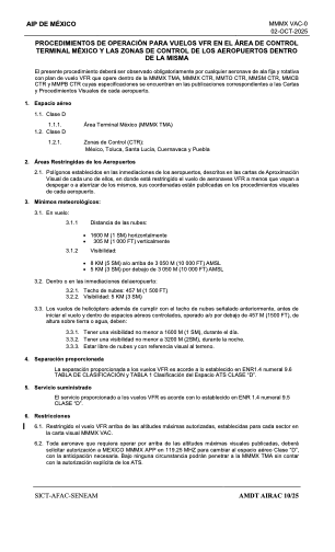
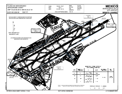


MMMX - Mexico Aeropuerto Internacional Benito Juarez
Located in Mexico, Mexico
ICAO - MMMX, IATA - MEX
Data provided by AirmateGeneral information
Coordinates: N19°26'9" W99°4'24"
Elevation is 7297 feet MSL.
View others Airports in Distrito Federal
Operational data
Special qualification required
Current time UTC:
Current local time:
Weather
METAR: MMMX 270025Z 06006KT 6SM TSRA BKN020CB OVC080 17/12 A3029 TEMPO 5SM TSRA RMK 8/96/ HZY OCNL LTGICCG SE
TAF: TAF AMD MMMX 270010Z 2700/2800 34010KT P6SM TS BKN020CB BKN080 OVC220 TX24/2720Z TN15/2712Z TEMPO 2700/2704 5SM TS RA FM270400 03005KT P6SM SCT020 SCT080 BKN200 PROB40 2709/2713 5SM RA BKN020 OVC080 FM271400 14005KT P6SM SCT020 BKN100 FM271900 23010KT P6SM BKN020 BKN100 BKN220 TEMPO 2721/2724 5SM TSRA BKN020CB
Communications frequencies: [VIEW]
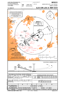
Runways:
| RWY identifier | QFU | Length (ft) | Width (ft) | Surface | LDA (ft) |
| 05L | 59° | 12861 | 148 | ASP | |
| 23R | 239° | 12861 | 148 | ASP | |
| 05R | 59° | 13432 | 148 | ASP | |
| 23L | 239° | 13432 | 148 | ASP |
Airport contact information
Address: Mexico Mexico