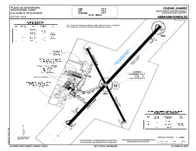


MMCS - Ciudad Juarez Aeropuerto Internacional Abraham Gonzalez
Located in Ciudad Juarez, Mexico
ICAO - MMCS, IATA - CJS
Data provided by AirmateGeneral information
Coordinates: N31°38'11" W106°25'44"
Elevation is 3904 feet MSL.
View others Airports in Chihushua
Operational data
Special qualification required
Current time UTC:
Current local time:
Weather
METAR: MMCS 271840Z 23014KT 10SM SCT030 22/M07 A2985 RMK 8/100
TAF: TAF MMCS 271743Z 2718/2818 24020KT P6SM SCT250 FM280600 27012KT P6SM SKC FM281700 29018KT P6SM SCT250
Communications frequencies: [VIEW]
Runways:
| RWY identifier | QFU | Length (ft) | Width (ft) | Surface | LDA (ft) |
| 03 | 39° | 8858 | 148 | ASP | |
| 21 | 219° | 8858 | 148 | ASP | |
| 15 | 156° | 5610 | 98 | UNK | |
| 33 | 336° | 5610 | 98 | UNK |
Airport contact information
Address: Ciudad Juarez Mexico