


M72 - New Albany/Union County
Located in New Albany, United States
ICAO - M72, IATA -
Data provided by AirmateGeneral information
Coordinates: N34°32'56" W89°1'28"
Elevation is 413 feet MSL.
Magnetic variation is -01° East View others Airports in Mississippi
Operational data
Special qualification required
Current time UTC:
Current local time:
Weather at : KTUP - Tupelo Rgnl ( 39 km )
METAR: KTUP 141519Z 19008KT 10SM FEW019 BKN025 OVC032 23/18 A2971 RMK AO2 T02280183
TAF: KTUP 141123Z 1412/1512 18007KT P6SM VCSH SCT007 OVC015 FM141800 22009KT P6SM VCSH BKN050 TEMPO 1419/1421 P6SM -TSRA SCT030CB OVC045 FM150100 23003KT P6SM VCSH BKN050 FM150500 24003KT P6SM BKN200
Communications frequencies: [VIEW]
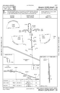
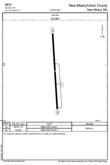
Runways:
| RWY identifier | QFU | Length (ft) | Width (ft) | Surface | LDA (ft) |
| 18 | 176° | 3903 | 75 | ASPH | |
| 36 | 356° | 3903 | 75 | ASPH |
Airport contact information
Address: New Albany United States